
Unused files
The following files exist but are not embedded in any page. Please note that other web sites may link to a file with a direct URL, and so may still be listed here despite being in active use.
Showing below up to 250 results in range #1 to #250.
View (previous 250 | next 250) (20 | 50 | 100 | 250 | 500)
 Circuit-court-sign2.jpg 230 × 173; 8 KB
 Courtroom.jpg 120 × 80; 3 KB
 Discussion group.jpg 400 × 267; 52 KB
 Discussion-group.jpg 400 × 300; 13 KB
 Puistopuu.jpg 385 × 266; 42 KB
 SalemWitchcraftTrial.jpg 400 × 304; 67 KB
 Thumbnail42.jpg 150 × 100; 8 KB
 Logo t10 small.jpg 354 × 286; 55 KB
 IMG 0948 edited2.jpg 454 × 340; 55 KB
 IMG 0948 edited3.jpg 318 × 238; 33 KB
 Tree for wiki.jpg 1,000 × 1,333; 490 KB
 Theme 6-2.JPG 640 × 480; 156 KB
 Portrait Theme8 Test.JPG 102 × 125; 3 KB
 Portrait Gabi.png 102 × 150; 27 KB
 Portrait Thijs Damsma.png 102 × 150; 30 KB
 Portrait Jan van de Graaff.png 102 × 150; 32 KB
 Portrait Josep Medina.png 102 × 150; 36 KB
 Portrait Tina Mertens.png 102 × 150; 32 KB
 Portrait Zbigniew Pruszak.png 102 × 150; 32 KB
 Protrait Theophanis Karambas.png 102 × 150; 31 KB
 Portrait no portrait.PNG 102 × 150; 396 bytes
 Portrait Michel Belorgey.png 102 × 150; 32 KB
 Theme6-2.jpg 640 × 480; 156 KB
 Dkboat.jpg 175 × 109; 6 KB
 Seabottom.jpg 175 × 128; 9 KB
 Seabottom2.jpg 175 × 170; 12 KB
 Theme 6 coastal.jpg 358 × 325; 19 KB
 Coralreef.jpg 150 × 113; 5 KB
 Coastfromabove2.jpg 717 × 478; 33 KB
 Measure.jpg 116 × 87; 2 KB
 ICZM.jpg 175 × 194; 28 KB
 IMG 0205.JPG 2,816 × 2,112; 340 KB
 ENCORA meeting2.jpg 2,816 × 2,112; 298 KB
 Example.jpg 500 × 273; 1.25 MB
 File.jpg 1,163 × 933; 272 KB
 Fot 1.jpg 1,009 × 628; 210 KB
 DBreakwater01.JPG 558 × 196; 17 KB
 US EPA 500px-Eutrophication en svg.png 500 × 327; 99 KB
 Eutrophication.png 500 × 327; 99 KB
 Eut NEDanishMarineWaters Danish EPA.gif 553 × 485; 39 KB
 Noctiluca miliaris bloom, German Bight, 2000.JPG 349 × 232; 21 KB
 Cyanobacteria bloom, western Baltic, 1997.JPG 133 × 160; 4 KB
 Seagrass.jpg 175 × 128; 9 KB
 EutrophicationSchematic.png 500 × 327; 99 KB
 Schematic.jpg 585 × 611; 84 KB
 Hallo.jpg 133 × 160; 4 KB
 GISCZM.jpg 1,329 × 758; 76 KB
 GISCZM2.jpg 758 × 445; 43 KB
 Sea.jpg 175 × 128; 9 KB
 Sandy coast.jpg 942 × 640; 72 KB
 Barrier coast.jpg 561 × 1,104; 116 KB
 Mangrove coast.jpg 703 × 519; 37 KB
 Littoral table.jpg 1,112 × 355; 77 KB
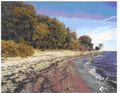 Exposed cliff1.jpg 726 × 563; 76 KB
 Exposed cliff2.jpg 768 × 600; 50 KB
 Monsoon1.jpg 726 × 521; 57 KB
 Monsoon2.jpg 768 × 600; 49 KB
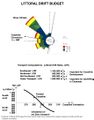
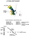 Drift budget.jpg 852 × 1,087; 83 KB
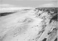 Exposed dune1.jpg 845 × 596; 58 KB
 Exposed dune2.jpg 768 × 600; 49 KB
 Increasing littoral drift rate.jpg 1,186 × 674; 144 KB
 Relation transport angle.jpg 1,890 × 1,096; 67 KB
 Detatched breakwater the one before.jpg 1,572 × 1,068; 82 KB
 Natural delta accretion.jpg 2,127 × 1,668; 140 KB
 Crescent correlation.jpg 1,275 × 1,534; 76 KB
 Detatched breakwater.jpg 2,025 × 1,419; 124 KB
 Initial sed trans the one before.jpg 1,018 × 708; 63 KB
 Initial sed trans.jpg 990 × 708; 50 KB
 Shoreline development schematic new.jpg 921 × 615; 59 KB
 Eutrophicationflow.jpg 809 × 70; 9 KB
 Koncept.jpg 512 × 528; 94 KB
 Backshore nourishment.jpg 867 × 948; 46 KB
 Nourishment methods.jpg 441 × 305; 24 KB
 Bds.jpg 450 × 193; 11 KB
 Slap-ton2.jpg 250 × 203; 22 KB
 Slapton2.jpg 1,139 × 653; 61 KB
 Overtopping.jpg 645 × 811; 80 KB
 Lee circulation a.jpg 1,013 × 710; 85 KB
 Lee circulation b.jpg 873 × 764; 130 KB
 Irregular storm.jpg 720 × 511; 59 KB
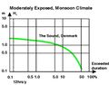
 Durationexceedence.jpg 418 × 258; 28 KB
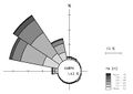 Waverose.jpg 365 × 259; 10 KB
 Scatter.jpg 434 × 238; 16 KB
 MIUoP.jpg 330 × 64; 7 KB
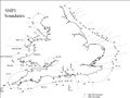 SMPboundaries.jpg 403 × 303; 19 KB
 Drift budget b.jpg 852 × 1,087; 91 KB
 Theme10 Flowchart StellaVallejo.jpg 960 × 720; 67 KB
 Shoreline development groyne.jpg 556 × 672; 63 KB
 Scheme.jpg 323 × 255; 28 KB
 Scheme2.jpg 323 × 255; 28 KB
 Fig.jpg 516 × 393; 35 KB
 Fig3 flexible mesh.jpg 520 × 443; 45 KB
 Fig5 San Stafano.jpg 440 × 324; 19 KB
 Fig6 wave modelling.jpg 464 × 338; 15 KB
 Fig7 sed trans pattern.jpg 440 × 230; 32 KB
 Fig8 current pattern.jpg 440 × 233; 24 KB
 Fig9 amager beach.jpg 556 × 566; 84 KB
 Fig10 wave patterns NE and SE.jpg 439 × 929; 80 KB
 Fig11 Amager Beach Park aerial photo.jpg 379 × 281; 15 KB
 Stepa.jpg 1,120 × 840; 154 KB
 Step1.jpg 1,120 × 840; 115 KB
 Step3.jpg 1,120 × 840; 102 KB
 Step4.jpg 1,120 × 840; 158 KB
 Step7.jpg 1,120 × 840; 125 KB
 Step8.jpg 1,120 × 840; 103 KB
 Stepb.jpg 1,120 × 840; 107 KB
 Stepc.jpg 1,120 × 840; 170 KB
 Stepd.jpg 1,120 × 840; 158 KB
 Step8b.jpg 1,120 × 840; 105 KB
 Theme01.jpg 423 × 497; 34 KB
 Theme01 50.jpg 212 × 249; 13 KB
 Theme01 70.jpg 297 × 348; 21 KB
 Theme02.jpg 212 × 249; 12 KB
 Theme03.jpg 210 × 242; 13 KB
 Theme04.jpg 210 × 249; 9 KB
 Theme05.jpg 212 × 243; 6 KB
 Theme06.jpg 212 × 249; 9 KB
 Theme07.jpg 210 × 242; 15 KB
 Theme08.jpg 211 × 249; 9 KB
 Theme09.jpg 212 × 242; 11 KB
 Theme10.jpg 207 × 249; 12 KB
 Theme01.png 170 × 200; 77 KB
 Theme02.png 170 × 200; 78 KB
 Theme03.png 168 × 199; 75 KB
 Theme04.png 171 × 200; 60 KB
 Theme05.png 170 × 200; 51 KB
 Theme06.png 168 × 200; 73 KB
 Theme07.png 168 × 200; 82 KB
 Theme08.png 169 × 200; 52 KB
 Theme09.png 170 × 200; 77 KB
 Theme10.png 169 × 200; 77 KB
 River USGS.jpg 640 × 480; 58 KB
 Zebra mussel invasive USGS.png 216 × 162; 90 KB
 Oiled bird.png 316 × 214; 147 KB
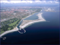 Fig11 Amager Beach Park aerial photo.png 570 × 427; 317 KB
 How to apply models schematic.png 458 × 651; 22 KB
 How to apply models schematic 2.png 458 × 651; 22 KB
 How to apply models schematic 3.png 462 × 651; 22 KB
 How to apply models schematic 4.png 473 × 691; 22 KB
 How to apply models schematic 5.png 477 × 681; 22 KB
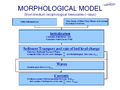 Morphological model short timescale.PNG 980 × 735; 126 KB
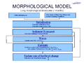 Morphological model long timescale.PNG 980 × 735; 129 KB
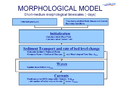 Morphological model short timescale smaller.PNG 794 × 596; 153 KB
 Morphological model long timescale smaller.PNG 794 × 596; 147 KB
 Figure10a wave patterns NE and SE.jpg 864 × 903; 109 KB
 Figure10b wave patterns NE and SE.jpg 864 × 903; 111 KB
 Irregular storm both.png 416 × 633; 326 KB
 Waves.jpg 175 × 166; 8 KB
 PoDelta.jpg 3,524 × 3,068; 1.8 MB
 Coastal profile.jpg 1,803 × 778; 128 KB
 Irregular storm both.jpg 850 × 602; 103 KB
 Refraction.gif 508 × 337; 50 KB
 Tidal currents.png 2,156 × 1,540; 66 KB
 Longshore distribution.png 810 × 362; 100 KB
 Crescent correlation new.png 1,275 × 1,534; 45 KB
 Natural delta accretion new.png 2,127 × 1,698; 292 KB
 Sediment balance.gif 412 × 230; 3 KB
 Fast ferry waves.gif 511 × 334; 50 KB
 Sediment overview.gif 542 × 378; 15 KB
 Nourished beaches equilibrium.png 1,004 × 779; 135 KB
 Nourish grain size.gif 533 × 295; 11 KB
 Beach drain fn.gif 595 × 234; 28 KB
 Derous Appendix 1 Page 1.jpg 1,654 × 2,339; 454 KB
 Derous Appendix 1 Page 2.jpg 1,654 × 2,339; 226 KB
 Derousetal Figure1.jpg 763 × 761; 140 KB
 Derousetal Figure.jpg 763 × 761; 140 KB
 Derous Table 2.jpg 1,654 × 2,339; 187 KB
 List of participants Page 1.png 1,654 × 2,339; 68 KB
 List of participants Page 2.png 1,654 × 2,339; 72 KB
 List of participants Page 3.png 1,654 × 2,339; 64 KB
 List of participants Page 1.jpg 1,654 × 2,339; 345 KB
 List of participants Page 2.jpg 1,654 × 2,339; 177 KB
 List of participants 1.jpg 1,654 × 2,339; 345 KB
 List of participants 2.jpg 1,654 × 2,339; 177 KB
 Figure1.png 550 × 353; 39 KB
 Figure2.png 720 × 540; 56 KB
 ModelsFigure3.png 720 × 540; 110 KB
 ModelsFigure6.png 720 × 540; 77 KB
 ModelsFigure8.png 720 × 540; 29 KB
 ModelsFigure9.png 720 × 540; 34 KB
 ModelsFigure10.png 720 × 540; 502 KB
 1 combination of waves currents and sed trans.gif 481 × 306; 18 KB
 2 project site.gif 275 × 202; 15 KB
 3 bathymetry behind breakwater.gif 481 × 241; 21 KB
 4 illustration full ts and compressed ts.gif 372 × 228; 10 KB
 5 results from morph model calibration.gif 481 × 216; 22 KB
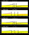
 6a. time series offshore waves.png 2,000 × 616; 19 KB
 6b. time series offshore waves.png 2,000 × 1,015; 33 KB
 6c. time series offshore waves.png 1,501 × 467; 9 KB
 8a illustration morph evol front of harbour.png 2,000 × 731; 17 KB
 8b illustration morph evol front of harbour.png 945 × 493; 8 KB
 1 combination of waves currents and sed trans.png 848 × 598; 91 KB
 State of the art.jpg 1,701 × 2,201; 88 KB
 Poulospic1um8.jpg 3,094 × 2,456; 344 KB
 Poulospic2.jpg 2,031 × 2,070; 667 KB
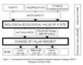
 Biodiversity elements.jpg 1,701 × 2,201; 219 KB
 Derous Figure1 new.jpg 1,417 × 1,889; 94 KB
 Derous new concept.jpg 1,417 × 1,889; 94 KB
 DPSIR.jpg 367 × 226; 18 KB
 Fig1.jpg 877 × 891; 92 KB
 Fig 1.jpg 292 × 297; 21 KB
 1138270948.Thu.Jan.26 10 22 28.GMT.2006.jvspeijk.c4.timex.jpg 768 × 576; 54 KB
 CPimage001.JPG 940 × 577; 110 KB
 Achtung-50.gif 50 × 41; 2 KB
 Achtung-90.gif 90 × 75; 3 KB
 Image003.JPG 924 × 541; 69 KB
 Image007.JPG 779 × 487; 29 KB
- Error creating thumbnail: File missingImage005.JPG 960 × 720; 43 KB
 Image006.JPG 960 × 720; 43 KB
 Radargeometrie.png 960 × 720; 84 KB
- Error creating thumbnail: File missingRDCP result new.png 960 × 720; 288 KB
 Rdcp result new.jpg 960 × 720; 150 KB
 RDCP Scheme.png 960 × 720; 61 KB
 Image009.JPG 729 × 314; 15 KB
 Dimi biomarkers4.jpg 473 × 113; 24 KB
 Dimi biomarkers5.jpg 412 × 292; 40 KB
 Accuracy.jpg 780 × 408; 121 KB
 Accuracy3.jpg 708 × 408; 121 KB
 Caixa1.jpg 960 × 720; 71 KB
 Stability.jpg 662 × 388; 36 KB
 Stability.JPG 370 × 199; 16 KB
 Stability1.JPG 371 × 201; 16 KB
 Theme9.PNG 170 × 200; 77 KB
 Theme9.png 170 × 200; 77 KB
 Channel coastal obs logo.gif 80 × 53; 3 KB
 Cobs.gif 370 × 65; 14 KB
 Pol logo50.gif 239 × 50; 2 KB
 BODC.gif 1 × 1; 43 bytes
 Banner.jpg 600 × 110; 11 KB
 Biodiversity elements2.jpg 1,228 × 689; 140 KB
 Zacharias.jpg 1,952 × 1,492; 415 KB
 Marchio scritta 72 piccolo.jpg 142 × 72; 23 KB
 Image1.png 34 × 36; 288 bytes
 Image5.png 206 × 72; 748 bytes
 Image6.png 24 × 28; 247 bytes
 Image7.png 140 × 48; 445 bytes
 WESP TRIPOD.jpg 592 × 860; 394 KB
 H534figure2.jpg 4,280 × 5,450; 1.13 MB
 H534figure1A.jpg 1,357 × 905; 159 KB
 Dataexample.jpg 248 × 408; 18 KB
 Zandkokerworm.JPG 1,600 × 1,200; 1.02 MB
 Physical.jpg 800 × 600; 79 KB
 Winddata.jpg 1,201 × 900; 70 KB
 Discharge.jpg 1,201 × 900; 62 KB
 TNObathymetry.png 1,201 × 900; 36 KB
 TNOd50.png 1,201 × 900; 36 KB
 TNOslib.png 1,201 × 900; 30 KB
 TNOslope.png 1,201 × 900; 45 KB
 Table part2.jpg 717 × 697; 153 KB
 Table part3.jpg 717 × 188; 62 KB


