Nautical depth of harbors and fairways
Definition of Nautical depth:
the depth where physical characteristics of the bottom reach a critical limit beyond which contact with a ship’s keel causes either damage or unacceptable effects on controllability and manoeuvrability” (PIANC 2014[1]). On nautical charts the nautical depth is indicated relative to a reference level (datum), usually lowest astronomical tide (LAT) or mean lower low water (MLLW) in non-tidal areas.
This is the common definition for Nautical depth, other definitions can be discussed in the article
|
Contents
Introduction
Harbors and fairways are preferential deposit areas for fine sediments. Maintenance of these areas at sufficient depth for safe navigation is a major cost item for harbor authorities. Much research has been done to understand causes and processes of siltation and to indicate possible solutions. This concerns in the first place the location and design of ports and fairways, see the article Siltation in harbors and fairways. Another important insight is that freshly deposited fine sediment that has not yet been consolidated is not necessarily a major impediment to shipping. This has led to the introduction of the concept of nautical depth. In the case of a silted bottom, the nautical depth is smaller than the water depth to the hard bottom, but possibly greater than the water depth to the surface of the mud bed. Accurate determination of the nautical depth therefore offers the opportunity to save costs on maintenance dredging.
Density criterion for nautical depth
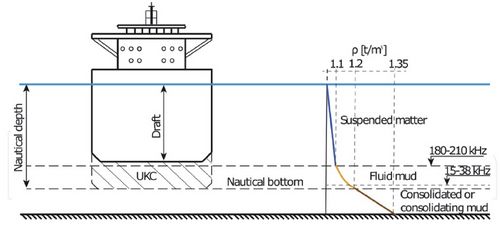
Freshly deposited fine sediment can be considered a viscoplastic substance that starts behaving like a viscous liquid (so called fluid mud) when subjected to a shear stress that exceeds a certain critical value (the so-called Bingham yield stress). Freshly deposited sediment through which ships can pass without major hindrance, has a high water content and low density. This is the case for fluid mud that has a density in the range of 1030–1300 kg/m3. Consolidation is slow as a consequence of hindered settling by the presence of flocs.as a consequence of hindered settling by the presence of flocs. The density of fine sediment deposits is therefore an important criterion for determining the nautical depth. Many ports, e.g. Rotterdam, Zeebrugge, Saint-Nazaire, Bordeaux, Shanghai, Bangkok, determine the nautical depth based on a density criterion[2]. The most usual value of navigable density is 1200 kg/m3, see Fig. 1.

Using the density as criterion for the nautical depth has some drawbacks.
The first issue is that the depth level corresponding to the density of 1200 kg/m3 cannot be easily determined. This level is not delineated by a sharp density interface on which acoustic signals reflect. This means that the density distribution must be determined at each location in different points over the vertical. This is a costly effort that can be done for example by sampling or with radioactive probes (a device with in one leg a radioactive source and in the other leg a scintillation detector from which the density can be derived).
The second issue is that the Bingham yield stress (or simply 'yield stress') is related not only to the density, but also depends on the type of sediment and its degree of consolidation[3].
A better criterion for the nautical depth is to define the acceptable yield stress of the mud bed for save navigation, rather than its density. The harbor of Emden has defined 100 Pa as acceptable yield stress[4].
Alternative methods for nautical depth determination

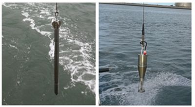
Alternative methods are based on measurement techniques from which the yield stress can be derived (Fig. 2). One of the tools is Rheotune that works in way similar to a tuning fork. Rheotune gives vertical profiles of (Bingham) yield stress and density at a given location. Spatial interpolation can be done by coupling the signal for an appropriate frequency of a seismic survey to the densities measured by Rheotune. This method (implemented through the so-called SILAS system) is currently used for detection of the nautical bottom in the Port of Rotterdam and in the Port of IJmuiden.
Another tool is the Graviprobe, a free-fall cylinder that penetrates the water mud column under its own weight. The Graviprobe measures the acceleration/deceleration of the cylinder, from which the shear strength and the yield stress can be determined by solving a force balance equation. Both the Rheotune and Graviprobe devices require laboratorium calibration with respect to the rheological properties of the site-specific mud.
The (Bingham) yield stress is a strongly increasing function of the degree of consolidation and thus of the density of the mud deposit. It also increases with increasing content of organic matter. Fluid mud layers have typical yield stress values below 20 Pa; for consolidated mud deposits (density of the order of 1700 kg/m3) the yield stress can be a factor 100 higher. Rheologic analysis shows that the viscosity of the fluid mud sharply drops when the shear stress is increased to about 5 times the yield stress[3].
Water Injection Dredging
Consolidated mud deposits that exceed the density and/or yield stress criteria must be dredged to restore sufficient nautical depth. Removal of dredged material is costly and dumping at a location not far out to sea entails the risk of return (recirculation) to the fairway. Water Injection Dredging (WID) to fluidize the mud deposit in the fairway can be an alternative. The fluid mud can leave the port with the ebb tide or by the action of gravity. Even if the mud is not evacuated, the nautical depth is at least partly recovered by WID since the yield stress of the fluidized bed is low[5]. However, the effect of the fluidization is not permanent because the fluid mud layer consolidates over time. It should further be noted that thick fluid mud layers can constitute a problem for the controllability and maneuverability of a vessel through the generation of internal waves at the water-mud interface (similar to the so-called dead water phenomenon in stratified water bodies). The internal waves affect the rudder and propeller efficiency in situations where the vessel's keel is just above the fluid mud layer[4]. Water Injection Dredging is currently practiced in the Netherlands, UK, USA, France, Germany and several other countries. For an overview of technical and environmental aspects of WID see for example the Water Injection Dredging Guidance Document (2015[6]). Other methods to minimize siltation-related maintenance costs of harbor and fairways are described in Siltation in harbors and fairways.
Related articles
References
- ↑ Permanent International Association of Navigation Congresses PIANC 2014. Harbour approach channels - design guidelines, 121
- ↑ 2.0 2.1 2.2 Kirichek, A., Shakeel, A. and Chassagne, C. 2020. Using in situ density and strength measurements for sediment maintenance in ports and waterways. J. Soils Sediments 20: 2546–2552
- ↑ 3.0 3.1 Shakeel, A., Kirichek, A. and Chassagne. C. 2020. Rheological analysis of mud from the port of Hamburg, Germany. J Soils Sediments 19: 1–10
- ↑ 4.0 4.1 Kirichek, A., Chassagne, C., Winterwerp, H. and Vellinga, T. 2018. How navigable are fluid mud layers. Terra et Aqua 151: 6–18 Cite error: Invalid
<ref>tag; name "K18" defined multiple times with different content - ↑ Kirichek, A., Cronin, K., Wit, L. and Kessel, T. 2021. Advances in Maintenance of Ports and Waterways: Water Injection Dredging. 10.5772/intechopen.98750
- ↑ Geode 2015. Water Injection Dredging Guidance Document. https://www.cerema.fr/system/files/documents/2018/02/Guide_methodo_DIE_trad_25-02-2015.pdf
Please note that others may also have edited the contents of this article.
|

